Best North America Map Cartoons and Educational Wall Maps for Homes and Classrooms
Explore the best North America map products that blend colorful, kid-friendly design with geographic detail. This guide highlights five top picks that suit classrooms, playrooms, and living spaces, offering durable lamination, reliable print quality, and engaging visuals. Each option emphasizes clear country boundaries, regional features, and educational value, making it easier to inspire curiosity about North America’s geography and landmarks.
Summary Table of Featured Products
| Product | Brand | Format | |
|---|---|---|---|
| Maps International Large Political North America Wall Map – Laminated – 48 x 36 | Maps International | Laminated Poster | Encapsulated lamination; detailed borders; hill and sea shading |
| North America Wall Map – Atlas of Canada – 34″ x 39″ Laminated | MapSherpa | Laminated Wall Map | Inset maps; road mileage table; 1:10,000,000 scale |
| Tot Talk North America Map Kids Placemat | Tot Talk | Double-sided Laminated Placemat | Made in USA; two-sided educational content |
| Washable Kids Rug 5×7 North America Map | Hazo Haus | Educational Rug | Iconic landmarks; non-slip backing |
| CoolOwlMaps North America Continent Wall Map Poster | Cool Owl Maps | Rolled Laminated Poster | Colorful country bands; USA states and Canadian provinces |
Maps International Large Political North America Wall Map

This large laminated political map covers North America with country boundaries, major towns and cities, and topographic shading. The lamination is described as encapsulation, sealing the print between industrial-quality plastic sheets for durability. While edges may not be sealed, the poster’s size (48 inches tall by 36 inches wide) provides a comprehensive view suitable for classrooms or large walls. It emphasizes continental context and easy readability, which can support geography lessons and family learning activities.
North America Wall Map – Atlas of Canada
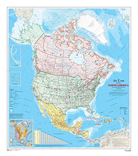
This laminated wall map measures 34 by 39 inches and is printed at a scale of 1:10,000,000. It offers detailed coverage of populated places, transportation routes, and the drainage network, with land areas colored by country. Inset maps show the Aleutian Islands, Hawaii, and relief features, plus a road mileage table between major cities. The flat map design is ideal for wall displays in classrooms or study spaces where students can explore continental relationships and travel distances.
Tot Talk North America Map Kids Placemat

Tot Talk’s placemats are designed for school-age children and families, featuring double-sided laminated content with learning topics on both sides. Made in the USA and safety-tested, these placemats provide durable, wipe-clean surfaces that support geography discussions during meals. The content is designed by subject matter experts and supports progressive learning, helping children connect geography concepts with real-world examples and storytelling prompts.
Washable North America Map Rug

This 5×7 foot washable rug features North American geography with landmarks like the Golden Gate Bridge, White House, and Mount Rushmore. The rug provides a soft play surface with a non-slip backing, making it suitable for playrooms, classrooms, or bedrooms. Its visual design supports imaginative play and helps children associate geographical features with recognizable symbols and sites, promoting hands-on exploration of the continent.
CoolOwlMaps North America Continent Wall Map Poster

This rolled laminated poster highlights country colors and banded boundaries, including USA states and Canadian provinces with capitals. Its bright, kid-friendly aesthetic supports classroom displays and home learning environments. The laminated finish helps protect the map from wear and tear, making it suitable for frequent handling by students or children during geography activities and crafts.
Buying Guide
Key purchase considerations help ensure you select maps that fit your space, user needs, and durability expectations:
- Purpose and setting: Choose laminated posters for wall displays and frequent handling, or placemats and rugs for interactive learning in homes or classrooms.
- Size and layout: Consider wall space and viewing distance. Large maps give broad context, while inset maps and scale details aid deeper study.
- Durability: Laminated or encapsulated finishes resist spills and wear, ideal for kids. Paper maps suit temporary displays or framing with protection.
- Educational features: Inset maps, road mileage tables, relief shading, and landmarks enhance learning by linking geography to real-world places.
- Design style: Colorful, kid-friendly palettes help engagement, but ensure readability for learners of different ages and vision needs.
- Assembly and placement: Rolling, tubed shipping, and ready-to-hang frames influence installation time and wall organization.
- Maintenance: Laminated surfaces wipe clean easily; fabric rugs require regular cleaning and stain resistance considerations.
In evaluating these options, consider whether you prefer a classroom-grade display with extensive insets and road data, or a more playful home accessory that fosters daily geography interactions. Price, shipping quality, and availability can also affect long-term satisfaction, especially for larger posters or wall rugs that define a room’s learning vibe.