Best Lake Erie Western Basin Fishing Maps for Anglers in the American Great Lakes
If you’re planning a Lake Erie Western Basin fishing trip, a reliable map is your best ally. This guide highlights five authoritative fishing maps that help identify GPS points, depth contours, and productive areas for popular species. The picks are best for boaters, shore anglers, and tournament-focused anglers who want clear, durable reference material. Each option serves different needs—from waterproof, pocket-friendly sheets to decorative 3-D wall art that celebrates the lake’s geography.
| Product | Best For | Key Strength |
|---|---|---|
| Lake Erie Western Basin Map, GPS Points, Waterproof Detailed Lake Map – #L127 | Boat anglers needing precise GPS data | GPS points and depth contours |
| Fishing Hot Spots Lake Erie Fishing Map, Central Basin West | Walleye and bass fishers in central basin | Durable, waterproof, shaded depth areas |
| Waterproof Charts, Lake Fishing, 128F Northwest Lake Erie & The Detroit River | Two-sided, foldable reference on the go | Foldable, tear resistant |
| Waterproof Charts, Standard Navigation, 68 Islands of Lake Erie | Standard navigation with large print | Two charts in one, easy readability |
| St. Clair/St. Clair River Fishing Map | Smallmouth and muskie enthusiasts near Lake St. Clair | Durable, clearly marked areas and boat accesses |
Lake Erie Western Basin Map, GPS Points, Waterproof Detailed Lake Map

Best for anglers who rely on precise GPS coordinates and depth features, this waterproof map emphasizes GPS points and depth contours. It’s compact for aboard a boat and robust for frequent use. Suitable for offshore skippers and shorebound anglers who want quick, accurate reference without fumbling for data. The waterproof construction helps in spray-prone environments, making it a dependable choice for repeat trips throughout the season.
Why selected: It pairs high-detail GPS data with depth contours, enabling targeted trolling and shoreline casting. Use this when you need reliable, field-tested information on Lake Erie’s western basin patterns. Caution: Ensure you carry a backup print or digital copy in case of surface wear over time.
Fishing Hot Spots Lake Erie Fishing Map, Central Basin West

Best for walleye concentration in the central basin, this map is part of a 3-map set and focuses on the central west area from Ruggles Beach to Geneva, OH. It’s constructed from durable, waterproof material with shaded depth areas to help identify temperature bands and structure. This map is ideal for anglers who fish the described corridor regularly and want a reliable, portable reference to guide day trips.
Why selected: It highlights the central basin’s main angling targets and uses waterproof shading to visualize depth. Choose this if your primary fishing zones include Ruggles Beach and Geneva, and you want a robust, easy-to-read sheet.
Waterproof Charts, Lake Fishing, 128F Northwest Lake Erie & The Detroit River

Best for anglers combining Northwest Lake Erie and the Detroit River, this two-sided, foldable chart offers tear-resistant, synthetic-paper durability. The compact format is ideal for quick references in the boat or at the dock, especially for anglers who navigate near river mouths and creeks that feed into the lake. It’s a practical choice for multi-location trips and travelers who value a lightweight, durable chart that’s easy to store.
Why selected: The two-sided design maximizes usable area while remaining portable. Use this when you need quick access to strategic zones near river outlets and the open lake. Caution: The sheet may not include every seasonal hotspot; verify against current regional guides before a trip.
Waterproof Charts, Standard Navigation, 68 Islands of Lake Erie

Best for broader navigation across the lake’s island chain, this two-chart-in-one option emphasizes standard navigation and readability. The large-print format supports anglers who prefer quick recognition of island groups, shoals, and channel routes. It’s well-suited for veteran boaters and newcomers who benefit from a clear, no-fruss layout when plotting routes through crowded or shallow waters.
Why selected: Its readability makes it a solid general-use map for recreational anglers who want a reliable reference that’s easy on the eyes during long days on the water. Limitation: It may not delve into advanced geological detail found in specialized maps—use as a primary guide supplemented by other sources when pursuing complex targets.
St. Clair/St. Clair River Fishing Map, Lake (MI/ONT)

Best for those pursuing smallmouth bass, muskellunge, walleye, and yellow perch near Lake St. Clair, this map situates the greater Lake Erie area within a broader ecosystem. It’s a durable, waterproof reference with clearly marked fishing areas and boat accesses, making it useful for skippers exploring routes into the St. Clair system. The map emphasizes access points and productive zones for multiple species, aiding planning for multi-species trips.
Why selected: It broadens the Lake Erie context to include St. Clair access points and fisheries. Choose this if your trips commonly extend into the St. Clair River region and you need marked boat accesses for safe journeys. Caution: Verify current waterway congestion and access restrictions before travel.
WOODCHART Lake Erie 3-D Nautical Map
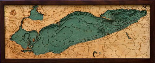
Best for display and decor lovers who also want a brag-worthy reference, this 3-D nautical map features laser-engraved Baltic birch layers forming a sculptural, wall-ready chart. It’s crafted by professional cartographers and is highly detailed for display purposes. This piece acts as a conversation starter while offering accurate topography cues for a visually rich interpretation of Lake Erie’s western basin and surrounding areas. It blends artistry with geographic accuracy.
Why selected: It adds an aesthetic, educational centerpiece for a study or living space while quietly providing geographic cues. Use as decor in a fishing cabin or office to celebrate your love of Lake Erie. Limitation: It is primarily decorative and not meant as a field navigation tool.
Buying Guide
What map type fits your fishing style?
- Boat-based navigation: Opt for waterproof, GPS-enabled or shaded-depth maps with durable materials for frequent exposure to spray.
- Shore anglers and casual trips: Choose large-print or two-sided charts with easy readability and island-area coverage.
- Decor and display: Consider 3-D or aesthetically designed maps that double as wall art without sacrificing essential geographic cues.
Durability matters. Look for waterproof, tear-resistant paper or synthetic materials. Foldable options are handy for portable use, while laminated sheets resist wear in rough weather. Depth contours and shaded areas improve your ability to locate structure that attracts fish.
Coverage and scale affect planning. Some maps focus on specific basins (central, northwest) or river connections (Detroit River, St. Clair). Decide whether you need a regional overview or precise hotspots for a single outing. Consider owning more than one map if you fish multiple zones or travel across the lake seasonally.
Compatibility with your gear is important. If you rely on GPS coordinates, ensure the map format aligns with your onboard electronics or printed backup. For decorative pieces, verify that the size and finish match your space and wall dimensions.
Frequently Asked Questions
- What is the best Lake Erie map for GPS coordinates?
Maps that emphasize GPS points and depth contours, like the Lake Erie Western Basin Map, are best for GPS navigation. - Are waterproof charts necessary for shallow-water fishing?
Yes, waterproof charts prevent water damage and keep critical data readable in spray-prone or wet conditions. - Should I buy multiple maps for Lake Erie fishing?
Yes, different basins and river connections offer distinct hotspots; a set improves planning and coverage. - Do decorative maps provide practical navigation?
Decorative 3-D maps are primarily for display; use technical maps for field navigation. - What should I consider when choosing between two-sided charts?
Two-sided charts maximize usable area and are easier to carry, but ensure both sides cover the zones you target. - Are these maps updated frequently?
Check product descriptions for update notes and verify data against current local charts before trips.