Best Peters World Map Guides: Proportions, Projections, and Practical Uses
Answering common buyer questions, this guide highlights the Peters projection family and closely related equal-area maps. These maps are best for educators, students, and planners who want land areas depicted in true proportion, avoiding Mercator distortions. The top five selections below emphasize accuracy, durability, and clarity for classroom walls or offices. A quick comparison of each option follows, helping you choose by intended use, size, and labeling quality.
Product Summary (Selected Models)
| Product | Projection Type | Size | Best For |
|---|---|---|---|
| Updated Peters Projection World Map | Updated Peters Projection | 36″ x 24″ | Educators seeking culturally equitable land-area representation |
| Gall Orthographic World Map | Orthographic (true size) | 36″ x 24″ | Classrooms needing accurate country proportions |
| Peters Equal Area World Map 24×36 | Peters Equal Area | 24″ x 36″ | Large wall display with true-size countries |
| Upside Down World Political Wall Map | Political World Map (inverted view) | 39.25″ x 27.5″ | Novelty display and critical thinking in geography |
| Laminated World Map & US Map Set | Equal Area / World and US set | 18″ x 29″ | Durable classroom sets for quick reference |
Updated Peters Projection World Map

Best for classrooms and offices prioritizing proportionally accurate land masses, this laminated Peters World Map presents continents in true size relative to one another. It includes clearly labeled countries, cities, and bodies of water, reducing bias from traditional map projections. The 36″ x 24″ laminated format is waterproof and dry-erasable for active teaching environments. It arrives rolled for safe shipping, not folded.
Who it’s best for: educators, aid organizations, and businesses needing culturally equitable geography visuals. Why selected: updated labeling and accurate land area depiction support geographic literacy with less distortion.
Limitations: some users prefer alternative projections for navigation or path planning; this map emphasizes land area accuracy over navigational accuracy.
Gall Orthographic World Map
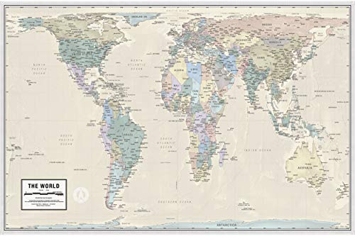
Best for students and teachers who need accurate country sizes in a visually clean layout, this map presents nations in correct proportion, addressing distortions common in Mercator projections. The 36″ x 24″ laminated poster uses archival inks on bright-white paper with a satin-laminate finish, shipped rolled to avoid folds. It is oriented for classroom wall display and quick reference during lessons.
Who it’s best for: geography teachers and homeschooling families prioritizing true-size comparisons. Why selected: it directly contrasts with Mercator distortions and supports proportional understanding.
Limitations: the orthographic view is best for proportional comparisons, not for navigation or travel routes.
Peters Equal Area World Map 24×36 Inches

This Peters projection option emphasizes equal-area representation with all countries shown at true size and true proportion. The 24″ x 36″ format is well-suited for medium-sized classrooms or conference rooms where a clear, size-appropriate display is needed. The map is designed to be durable and easy to read from a distance.
Who it’s best for: larger classrooms or meeting spaces seeking an authoritative equal-area map. Why selected: straightforward equal-area depiction helps students compare continental sizes accurately.
Limitations: edge labeling and detail may be less prominent on smaller displays compared to larger formats.
Swiftmaps World Premier Wall Map

Best for portable visualization and quick display in environments where a folded edition is preferred, this map uses 3D shaded relief to emphasize terrain alongside a world view. The folded format reduces shipping size and is suitable for temporary displays in classrooms, conference rooms, or presentations. It is designed for easy storage when not in use.
Who it’s best for: teachers and presenters needing a compact, foldable wall map with terrain cues. Why selected: portability and 3D relief offer a different teaching tool while preserving a global view.
Limitations: folded editions may require careful unfolding and flattening for optimal readability in permanent wall installations.
Upside Down World Political Wall Map

Best for critical thinking exercises and classroom discussion, this political world map offers a flipped perspective to prompt questions about standard views and conventional wisdom. The 39.25″ x 27.5″ map is printed on paper and shipped tubed for safe transit. It provides a striking, conversation-starting alternative to traditional layouts.
Who it’s best for: educators incorporating creative geography activities or debates. Why selected: its inverted perspective challenges assumptions and encourages discussion.
Limitations: not designed for navigational accuracy or precise proportion comparisons.
2 Pack – Laminated World Map Poster & USA Map Set

Best value set for classrooms needing multiple reference maps, this 2-pack includes a world map poster and a US map with equal-area presentation. Each poster is 18″ x 29″ and features durable 3-mil lamination for longevity in busy educational spaces. The pair is shipped together and stored easily when not in use.
Who it’s best for: schools and homeschool setups seeking a cost-effective array of essential references. Why selected: combined set offers balanced coverage of global and regional geography with durable lamination.
Limitations: smaller wall space may limit legibility from a distance compared to larger formats.
Buying Guide
- : Choose Peters Equal Area or Updated Peters if land-area accuracy is the primary goal. For true-size comparisons, these projections reduce common distortions found in Mercator.
- : Larger maps (36″ x 24″ and bigger) offer clearer labeling for classrooms. Lamination enhances durability and dry-erase compatibility.
- : Verify country, city, and water body labeling. Some maps emphasize political boundaries, others focus on physical features or relief shading.
- : Laminated maps resist spills and fading. Rolled shipments prevent creasing; folded editions save space but require flat setup.
- : If teaching proportional geography, prefer equal-area or Peters designs. For navigation-focused activities, consider traditional navigational projections separately.
- : Bundled options (e.g., world plus US maps) provide value for multi-station classrooms. Compare lamination thickness and paper quality when possible.
FAQ
- What is the Peters projection? It is an equal-area projection that preserves land area relative to other landmasses, reducing traditional distortions found in Mercator.
- Which map is best for teaching true continent sizes? Peters projections and Equal Area maps are designed for accurate relative sizes between continents.
- Are laminated maps more durable? Yes. Lamination protects against spills, signs of wear, and allows dry-erase use in classrooms.
- Do these maps show political boundaries clearly? Some prioritize political boundaries; others emphasize land area or physical features. Check the product features for labeling focus.
- What size is best for a classroom wall? For most classrooms, 36″ x 24″ or larger provides comfortable readability from typical seating distances.
- Should I buy a two-pack map set? If you need multiple reference maps for different areas (world and US, for example), a set offers cost and space efficiency.